
- 12V Accessories
- 4WD & TOURING
- 4WD & TOURING BARWORK & PROTECTION SIDE RAILS & STEPS
- 4WD & TOURING BARWORK & PROTECTION UNDERBODY PROTECTION
- 4WD & TOURING BARWORK & PROTECTION WINCH BARS / BULL BARS
- 4WD & TOURING Towing Mirrors
- 4WD TOURING
- 4X4
- 5th Wheel & Gooseneck
- ACCESORIES & TOURING
- ACCESORIES & TOURING Roof Rack Accessories
- ACCESSORIES
- Accessories
- Accessories
- ACCESSORIES
- ACCESSORIES
- ACCESSORIES & KITS
- ACCESSORIES 4x4 ACCESSORIES
- ACCESSORIES Power Pack
- BACKYARD & BEYOND
- Bash Plates
- Battery Trays
- BOOTS
- BULLBARS & PROTECTION
- BULLBARS & PROTECTION Front Protection Bars
- BULLBARS & PROTECTION Premium Roll Bar
- BULLBARS & PROTECTION Rear Carrier Bars
- BULLBARS & PROTECTION Rear Protection Bars
- BULLBARS & PROTECTION Rock Sliders - Side Setps
- BULLBARS & PROTECTION Rock Sliders - Side Setps
- BULLBARS & PROTECTION SINGLE LIGHT BAR
- BULLBARS & PROTECTION Sport bar
- BULLBARS & PROTECTION Steel Bullbars
- BULLBARS & PROTECTION Underbody Protection
- CAMPING & OUTDOOR
- CANOPIES & TRAYS
- CLASSIC SPORT BAR
- Clothing
- CLOTHING MENS JACKETS
- COMMUNICATIONS Accessories
- COMMUNICATIONS Accessories
- Diff Drop
- Dual Battery Management
- ELECTRICAL Battery Trays
- ELECTRICAL LIGHTING LED LIGHT BAR
- MARINE AUDIO
- MARINE CASES
- MARINE COMMUNICATIONS
- Performance
- PHOENIX BARS
- Rock Sliders & Bars
- Roll Bars
- SAFARI
- SAFARI
- Safety and Recovery
- SAFETY AND RECOVERY Recovery Point
- SAFETY AND RECOVERY Recovery Points
- SAMMITR
- Scanners
- SINGLE LIGHT BAR
- Snorkels
- SNORKELS
- Sport bar
- STORAGE
- SURVEILLANCE
- Suspension
- SWING SPORT BAR
- TOWING & TRAILERS
- TRAILER & TRUCK PARTS
- TYRE RACK
- UHF & TRANSCEIVERS
- UHF HANDHELD RADIOS
- WINCH BARS / BULL BARS
- WINCHES
- WINCHES & RECOVERY Electrical Winches
- NUDGE BARS
- REAR BARS & WHEEL
- ALUMINIUM BARS
- SIDE RAILS AND STEPS
- UNDERBODY PROTECTION
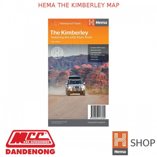


HEMA THE KIMBERLEY MAP
- $14.95
Product Details
- Brand: HEMA MAPS
- Product Code: 9781876413705
- Availability: In Stock
Description:
A regional map of the Kimberley that features the iconic Gibb River Road. On the reverse are inset maps for Purnululu National Park, the Dampier Peninsula and the Parry Creek area. There is also extensive drive detail and trip coverage for the Gibb River Road.
- Waterproof paper
- Detailed 4WD tracks
- National parks
- Camping areas
- GPS surveyed roads & tracks
This new edition of Hema’s best-selling Kimberley map features our latest mapping and points of interest in a stunning new cartographic style. It combines Hema’s entire database of remote roads and 4WD tracks with touring points of interest and topographic information.
This waterproof regional map of the Kimberley features the Gibb River Road. On the reverse are inset maps for Purnululu National Park, the Dampier Peninsula and the Parry Creek area. Detailed trip coverage and drive detail for the Gibb River Road is featured as well, with inset mapping covering the journey and corresponding text to guide explorers.
Also included is national park information and relevant contact details for pre-trip planning and use on the road or track.
| HEMA MAPS SPECIFICATIONS | |
| Availability | Available |
| Format | Folded Map |
| Publication Date | 21/03/2017 |